John Bartholomew's Half Inch Maps: 1895 - 1960

1. The Bartholomew Company and the Development of the Half-Inch map series until 1960.
The Bartholomew Company
The first in a long line of engravers, George Bartholomew was not the real founder of the Bartholomew family business, this would be John Bartholomew, George's son. Daniel Lizars was a successful and well-respected engraver with his own business. One of his apprentices would be George Bartholomew (1784-1871) and George would be working for Lizars from 1797 in Edinburgh carrying out a wide variety of work including town plans such as those of Edinburgh in 1825 and 1829, published by J Lothian of St Andrew Square. But George was a journeyman working for anyone who required his skills and, later in life, being employed by his son. It is this son, John Bartholomew (senior) who will become an independent businessman and found the company of John Bartholomew and who will focus a lot of the firm's attention on the production of maps.
John
Bartholomew was born in 1805. He finishes his apprenticeship in 1826 and within
two years has established himself as an engraver to whom the company Gray &
Son of Glasgow turns to help when another engraver lets them down. Perhaps the
Directory Plan of Edinburgh, carried out for W & D Lizars in 1826, is his
first cartographic work. If it is, it was a landmark for the company and gave
the firm the direction it would generally take for the next two hundred years.
At this time he is at 4 East St James Street, at the east end of Edinburgh's
Princes Street.
By
1855 Bartholomew is married with five children and living at 59 York Place. His
son Henry, born in 1834, is employed along with five engravers and apprentices
and John's father. Meanwhile John junior, born 1831, has been studying the
engraving arts by spending two years with Augustus Petermann at Justus Perthes'
London office. Despite the allure of the offer of working for Perthes in Gotha,
Prince Albert's home, John returns to take the reins of his father's business.
John senior relinquishes control of the company in 1859 after seeing the
company move to larger premises at 4 North Bridge. Two years later, when he dies, the wages bill
of the company runs to £1000 p.a.
Bartholomew and County Mapping – Black's Guides 1862
Black's guides appeared from 1855. Besley's Route Book to Devon appeared in 1845 and five years later John
Murray published the first of his long series of Devon Handbooks. Originally
combining
Established in
The maps which were used were taken from Black’s Map of England and Wales which, as well as appearing in some
atlases, was published as a folding map Black’s
Road & Railway Travelling Map of England. This was engraved by S Hall, Bury St. Bloomsbury. This was the company of Sidney Hall who died in 1831; his daughter,
Selina, took over the business after his death and Edward Weller (c.f.)
acquired the business on the death of Selina.
From the Guide’s beginnings a map of the area was
included, and in the 1855 issue it was a map of Devon and Cornwall engraved by Friedrick
Schenck[1] and William Husband M’Farlane. Although the title page is dated 1855, copies of the guide so far seen
were issued later as revealed by careful scrutiny of the advertisements. The
railways shown are somewhat anticipatory, Exmouth was opened in 1861 and Truro
was not reached until 1865 although both are shown. How often the guide was reissued is not known;
however, it must have seemed promising as the Black's published a new edition
in 1862. This was issued as a combined volume including Dorset, Devon and
Cornwall but also the counties were published separately (142). The series was so successful that editions were reprinted
almost every year until the end of the century and a new Bartholomew map was
included when the text was extensively revised in 1882 (150).
Emil
Ernst Friedrich Theodor Schenck was born in Offenbach, Germany, in 1811 and
died in Edinburgh in 1885. After training as lithographer and artist in Munich
and Paris, he moved to Edinburgh in 1840 at the invitation of Samuel Leith. He proceeded to give talks on lithography to the
R.S.S.A. and was later awarded their gold medal. He also wrote the article on
lithography for the 8th edition of the Encyclopedia
Britannica. At the time that the first Black’s guides of Devon appeared he
was working with William Husband M’Farlane but the partnership was dissolved in 1859. Although
Macfarlane[2]
continued as Schenck and M’Farlane, Schenck had set up again as
Friedrich Schenck. His son,
Frederick, was taken into partnership, but the partnership only lasted 1866-1868.
Friedrich Schenck retired in 1875[3].
Among the earliest involvements of John Bartholomew in English county mapping was his series of
maps used from 1862.[4] Bartholomew drew and
engraved a map (possibly of England & Wales) and a transfer was issued in Blacks Guide to the South Western Counties
of England (1862). This was a map of
Dorset, Devon & Cornwall. From c.1869[5] the map of
Although McFarlane's name appears on the first map, the guides were printed
by R & R Clark of Edinburgh, and were reprinted almost every
year with little or, more often, no change to the text as shown by the fact
that the pagination for
Bartholomew and County Mapping – Imperial Map 1868
Among
the earliest involvements of John Bartholomew II (1805-1861) in English county mapping was
his engraving of the Imperial Map of
England & Wales, published in 1868 in atlas form
on 16 sheets.[6] The
publisher of the Imperial Map was
Archibald Fullarton, who commissioned it to replace the earlier maps from his Parliamentary Gazetteer (B&B 107)
which were very out of date by this time. Although a wide variety of sectional
maps of England and Wales were prepared from the plates,
they were only used to produce county maps, i.e. maps of a single county
on one sheet, for two other publishers and one local Plymouth publisher.
Throughout the life of these plates updated transfers at different sizes, of
different areas were taken to produce regional
maps, excursion maps and local guides for other publishers such as A & C
Black, W H Smith (Fig. 1), Houlston & Wright, Houlston & Sons, Milligan & Co., Hiorns
and Miller, Abel Heywood and Charles Pearson[7]. During this period Bartholomew's own Royal Atlas appeared using the same map as base and with the
sectional, not the county, approach. In the twentieth century the plates were
still being used to make maps for Varnan Chown & Co[8]., G W Bacon & Co.,[9] and also for Darlington’s Devon
and Cornwall guide (c.1908).
Transfers were also taken for sectional maps for Dulau and Co’s guides, i.e. the Thorough
Guides series[10],
from 1882.
The
first county map of Devon (B&B 150) seen taken from the Imperial Map was a folding lithograph
map published by John Heydon, printer, stationer and
book-seller in Devonport, according to White's Gazetteer of Devonshire, 1850. In 1857 Heydon was advertising
himself as Bookseller, Stationer,
Printer, Music Seller, News Agent, &c. at 104 Fore Street Devonport and
47 Treville Street in Plymouth (Billing´s Directory).
He was also a major seller of second-hand and new books for sale at very low prices. How Heydon
came across the map or why he added the Plymouth Forts is unknown[11].
He possibly sold it as a tourist's map of

The map of
The Imperial Map was
continually updated and W H Smith used it for their general Series of Tourists‘ Maps & Plans of
England. The series included North and South Devon, Environs of Plymouth and Environs
of Exeter (Fig. 1). These were issued at periodic intervals up until the 1890s.
Black’s Guide To Devonshire included Bartholomew’s map in all editions after 1882 (see 142). Originally the guide, printed by
R & R Clark of Edinburgh, contained two maps: a sketch, or
index map on the inside front cover; and
the county map, taken from the Imperial
Map. The county map was originally on two sheets inserted between text
pages, in the fourteenth edition it was on four sheets and later it was a
single sheet, folded and located in a pocket formed carefully on the back
cover. In 1892 Black's guide was
extensively revised by "C W", probably Charles Worthy who had also edited some of
In the early 1880s the company of Dulau & Co. began publishing a series of Thorough Guides with the first volume on the English Lake District. Subsequent volumes covered tourist areas such as
Mountford John Byrde Baddeley (1843-1906), a school master, earned his reputation as the compiler of these Thorough Guide books for pedestrians. He
settled in the
The Devon guides were printed by either Strangeways
& Sons or by J S Levin (1885, 1888, 1889, 1890).
Bartholomew
took transfers from the Imperial Map
to provide sectional maps for guide books (e.g. Dulau and Co’s Thorough Guides series, 157). From March 1899 to May 1900 transfers of the Imperial Map were again taken to produce a set
of regional maps. These were published in 20 parts to produce The Royal Atlas of England and Wales (Edited by J Bartholomew and
published by George Newnes Limited).
The
reverse is titled Pattisons` Scotch
Whisky is invaluable to all Travellers & Sportsmen Abroad or at home who go
in for Cycling - Golfing - Curling - Hunting - Coaching - Yachting - Shooting -
Fishing and there are delightful little engravings of each of the sports
listed and the addresses of the Pattisons company. The maps were used to
advertise the company floated by Robert and Walter Pattison in 1896 and 15 maps of
The
plates of both these
Abel
Heywood’s series of Penny Guide Books included transfers from the Royal Atlas. A map covering most of
Bartholomew and County Mapping – Encyclopaedia
Britannica 1877
The first Encyclopaedia Britannica appeared in three volumes in 1768-71 under
the auspices of a Society of Gentlemen.
Andrew Bell (1726-1809) founded the Encyclopaedia
Britannica with Colin McFarquar. On
The Americans appreciated the Encyclopaedia in a big way and soon
Blacks were selling more copies there than in Britain. The firm of Little,
Brown of Boston were official agents with Charles Scribner's Sons (New York)
covering subscription volumes. The latter reported sales of 18,000 sets as
early as 1879. However, there was also a flourishing pirate trade (British
authors were not given full copyright protection until 1957!). Indeed, the Encyclopædia Britannica first appeared
in the United States in the form of a pirated edition printed in Philadelphia
in 1790 by one Thomas Dobson. Among its purchasers were George Washington,
Thomas Jefferson, and Alexander Hamilton. Its American success resulted the Blacks
being approached by James Clarke & Co. for the rights to reprint and sell 5000 copies
in 1897.
In 1898 a full-page
advertisement for The Encyclopaedia
Britannica. A Dictionary of Arts, Sciences, and General Literature appeared
in The Times. The success was astonishing
with new reprinting being needed immediately. By 1899 James Clarke & Co.
had bought the copyright.[19] W & A K
Johnston must have taken over printing of the maps at
about this time.
In 1892 Black’s Handy Atlas of England & Wales appeared using the Britannica maps. The

Fig. 2: An example of Bartholomew's experiments in hill shading.
W H Smith was founded c.1820 by Henry
Edward and his brother William Henry (who actually
ran the company).
But it was not until Henry’s son, also William Henry (1825-1891), became a
partner in 1846 that the firm became the well-known booksellers and stationers.
In 1848 he started a newsagent shop at Euston with a concession from the
L&NW Railway. This was soon to be converted into a virtual railway
book-stall monopoly. The firm soon became the largest newsagent in the country
and expanded further into circulating libraries. William Henry later entered Parliament and
became the First Lord of the Admiralty in 1877 (Gilbert & Sullivan’s HMS
Pinafore was supposedly based on him).[20] W H Smith used to have an estate in Rewe in east Devon where he had a
stable built opposite St Mary the Virgin church for the use of the parishioners
so that they could tie up their horses.[21]
At the same time as the map below was on sale a similar map of North
Devon was also being offered in the same red covers. This covered an area
slightly further north, ie the whole of the north Devon coast as far east as
Burnham in Somerset and south only to Teignmouth and Tavistock. This was taken
from the same map plates.[22]
However, John Bartholomew was known
to be experimenting with hill shading in the 1880s and the Bartholomew records show
various printings of this map in the years 1884-1887 (probably referring to the
first one below). Two maps have been found, both executed by the Bartholomew
company and both sold in W H Smith covers, and displaying attempts at portraying
heights. The first used a very harsh hachuring to achieve hill shading: four
separate versions of this map have been found but the actual sequence remains
unclear and all seem to have the same map detail, the differences lie in
imprint, railways and covers. A later version uses a very subtle brown tone
(Fig. 2) to give the impression of height. These seem to be the precursors for
Bartholomew's Reduced Ordnance Survey Maps
published in 1895/1896.
Bartholomew Half Inch Series and cover designs
From 1875 John Bartholomew
& Co. had been publishing a series of maps of
The maps had a long and varied
life. The first sheets with colour contouring (

Fig. 3: Early covers: Brown for paper and blue for linen mounted maps.
The original folding maps simply have a title consisting of North Devon or South Devon (centrally) plus a subtitle Reduced Ordnance Survey of England and Wales (together with the scale) top left. However, from 1898 the map series was numbered - South Devon became 36 (1898) and North Devon became 35 (1899) – and the map title changed to Bartholomew's Reduced Ordnance Survey of England and Wales (centrally with scale) and the previous title became a subtitle (top right, with sheet number top left). From this time the logo of the Cyclists' Touring Club appears on the reverse of the map cover and from 1902 also on the map. Bartholomew published and sold these maps, either on paper (in brown covers at one shilling) or mounted on cloth (2/-) under his own imprint from The Geographical Institute, first in Park Road and from 1911, Duncan St., Edinburgh.
Originally the cover title was
Bartholomew's Reduced Ordnance Survey ...
Coloured for Tourists & Cyclists above and below a sticker with the
title of the map. Fig. 1 shows the brown paper cover of South Devon and the
scale. At the end of the century the title was changed to Bartholomew's New Reduced Survey above the sticker which now had
the sheet number added, e.g. Sheet 35 for North Devon. This design persevered
until circa 1929. Fig. 3 also shows
the blue cover of this later series for a linen mounted map of North Devon.
Although most maps were
published, and presumably, distributed by, Bartholomew's the company also had
arrangements to provide other publishers to distribute the maps. George Philip
and Son were a very successful and well-known publisher of maps in their own
right and Bartholomew's printed covers especially for them; all copies seen are
the same design as for Bartholomew's own maps but in red with Philip's address
printed on the cover (not on a label, see Fig. 12).
Other mapsellers
and geographical booksellers sold the maps: Alfred Wilson, Map and Bookseller
in Church Street, London, sold the maps mounted on linen; and Sifton Praed and
Co. Ltd, of 67
St James's Street, London, offered the maps as boxed sets in leather cases.
Both of these had specially printed covers and the maps were distributed to
members by both the RAC and the AA in distinctive covers (Figs. 4 and 5).

Fig. 4: Maps produced for the Automobile Association and Motor Union.

Fig. 5: Maps produced for the Royal Automobile Club.
Early in the 20th century G W Bacon was selling maps produced from the same plates but without the layered colour. Bacon's New Half-Inch Maps Cycling and Motoring Devon was a map of the county covering the area of both the previous maps folding to pocket size. A larger example folding into boards 240 x 190 mm (unfolding to 1150 x 730 mm) was Bacon's New Library Map Of Devonshire And Part of Somerset. These were both the same plates as before but the layout was substantially different. In both, parts of east and west Devon were included in inset maps and the New Library Map had an Alphabetical Index-Gazetteer together with a Table of Distances By Road below. These maps did not utilise the layer printing (i.e. not hypsometrically tinted) and were either uncoloured or with standard colour printing.

Fig. 6: New names were introduced for the sheets circa 1924.
The cover design
was radically altered about 1929 (based on North Devon, Fig. 7). The more
"modern" design incorporated the Royal Arms top and advertised Cartographers by Appointment to the King.
The series was now Bartholomew's Revised "Half
Inch" Contoured Maps. Between 1935 and 1942 new numbering was
introduced to create a British Isles set starting with no. 1 Cornwall,
consequently South Devon now became sheet 2 (Dartmoor)
and North Devon became sheet 3 (Exmoor). The transition in numbering took quite a long time and the
first map covers only the number of the old series. The following variations to
the North Devon/Exmoor map have been seen:
- Price only at top, and the title at bottom is England Sheet 35 North Devon.(A29)
- Price and number 35 (top
right) only and the title at bottom is England
Sheet 35 Exmoor.(B35)
- Number Eng. 35 (top right) and 3 (top left) and title at bottom is
Great Britain Sheet 3 Exmoor.
(B45) (Dartmoor in this form seen, B42).
- Only number 3 (top left)
and the title at bottom is Great
Britain Sheet 3 Exmoor. (1948)
- Number 3 (top right and top left) and title at bottom is Great Britain Sheet 3 Exmoor. (1950) (Dartmoor seen in this form 1948)

Fig. 7: New modern covers post-1929.
The last change
coincides with the introduction of Exmoor to the top of the cover between the
numbers. While the first of these covers had by Appointment to the King
this changed to by Appointment to the Late King George V after
his death (January 1936). Also at
this time a policy of only issuing maps dissected and mounted on linen must
have been made. No maps with this design have been seen in covers; the front
and back covers are two sheets pasted on.
This changed over
the years: The red and white design (not considered here) was introduced in
1961 with the thumbnail map of the area covered. The North and South sheets were
still on sale up to the 1970s but the introduction of metrication with a scale
of 1:100,000 brought about the demise of the half inch maps some 100 years
after the original Scottish series and 80 years after the English maps.
Advertising insert
slips
From very early on, pages were
pasted onto the back of the map (i.e. not on the cover), only being revealed
when one opened the covers. The number of pages inserted in this way varied and
the actual text was also updated.
The 1896 edition of south
Devon appeared with three extra sheets. The first was an index map of completed
sheets of the Reduced Ordnance Survey of
England and Wales. The map showed England and Wales divided up into (map)
squares with 16 squares coloured to show availability of a map for that area:
1, 8, 11, 15, 18-20, 25, 26, 30-37 omitting 34. This represented the Scottish
border by Berwick, Manchester, Caernarvon, a broad backward "C" area
to include Birmingham, the east coast, London to New Forest and Devon and
Cornwall. The other two sheets composed of an alphabetical list of maps in The Pocket Series of Touring Maps
numbered from 1, Aldershot and Environs, to 127, Wiltshire. A list of Tourists' and Cyclists' General Maps and
the World Series of Touring Maps
followed. This list included two Aldershot maps and a map of Suffolk (see
below).
Two years later a total of four sheets were
included. The four pages were now:
- Reduced Ordnance Survey of England and Wales with index map
of completed sheets
- Reduced Ordnance Survey of Scotland with index map
of completed sheets
- List of
special district maps and town plans
- General maps
for tourists and cyclists
As the England and Wales
sheets were not all completed early examples of the first sheet show
differences in the number of squares (i.e. sheets) coloured in to represent
maps available. The number of sheets completed rose steadily and maps with 20,
21, 22, 26, 27, 32 and 37 (i.e. series complete) have been seen on Devon maps. Fig. 96 shows two identical maps (South Sheet state 2) of 1898 but with different
index maps. At a later date (c. 1910) circles were added to the sheet numbers.
As the Scottish series was
completed before the England and Wales series the index map on the second
pasted insert is the same throughout except for minor print changes. About
1910, when Ireland was included, a new index page was printed with both index
maps of Scotland (top) and Ireland (bottom) on the same page, and advertising
text.

Fig. 8: Two index maps showing series progress.
- The Pocket Series of Touring Maps in single
column stretching over two pages
- List on one
page in two columns with Aldershot
& Envs and Aldershot Camp & Environs and Suffolk County
- The Pocket Series of Touring Maps
- W H Smith & Son's Series of
Travelling Maps
- Aldershot Camp map has been omitted but Suffolk County is present
- Suffolk County omitted

Fig. 9: Sticker inside the Bartholomew map advertising
W H Smith & Son's Series of Travelling
Maps.
By 1901 the Pocket Series was complete and a new
section was included on page three with Special
Cyclists' Maps (of Birmingham, Leeds
and Sheffield, and Manchester and Liverpool districts). London north and south
(i.e. 2 maps) were added a few years later.
The list of other map publications and the overview map of England & Wales became a standard feature on all maps published by and for Bartholomew until approx. 1935. In the maps listed below the 1929 and 1935 (North Devon, Fig. 10) issues have a blue label advertising Bartholomew's Pocket Atlases (with the addition of Liverpool and Birkenhead for the latter). On the introduction of the new cover design the list of other publications (blue) was inserted in the 1935 issue but in white and then ceased to be included. The overview map was kept at least to 1960 when this survey finishes.

Fig. 10: The 1929 and 1935 (North) insert pages
1. No list of other maps
2.1 and 2.1 Tourist's Map of Egypt
3. Commercial Map of Australia
4. Oceania and the Pacific
Types
of roads
The first issues of the maps had the key to the different types of roads to be encountered under the map border. In the earliest editions the roads were split into two types: Driving & Cycling Roads and Other Roads. Fig. 11 shows the first state (1896) of South Devon.
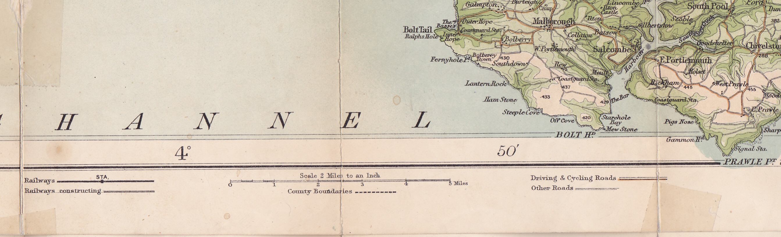
Fig. 11: Types of roads - first state (1896) of South Devon.
Two years later the note on
roads was moved to the map area (bottom right on the south sheet). The roads
are still split into two types: Driving
& Cycling Roads and Other Roads.
Fig. 12.

Fig. 12: Types of roads - second state (1898) of South Devon.
By 1901 the
Explanatory Note is now contained within a box border. Cycling Roads becomes Cycling
Routes. This panel was considerably changed between 1902 and c.1905. There
are First Class Roads, there are Secondary (roads) as well as Indifferent
(roads). In addition there is a key to Footpaths and Bridlepaths. For the
intrepid cyclist there is even a note on dangerous hills with arrow
representations added to roads with steep gradients. This latter note was
omitted very soon after. At this time the height bar was from Sea Level to Above 2000 (feet).

Fig. 13: States of South Devon with Explanatory Note and height bar.
Between 1905 and
1910 the Explanatory Note was again
revised. The roads are as before but the note on dangerous hills has been
omitted. Canals are introduced. The height bar was also altered at this time
and now begins Low Tide to 5 Fathoms.Fig. 13.
About 1910 the note on roads was again updated. The Explanatory Note now reads: First Class Roads then Through Routes and Secondary (Routes).

Fig. 14: Map distributed by George Philip c. 1910 with
Explanatory Note and height bar.
In 1916 the table has been revised to read: Motoring Roads: Through Routes and First Class Roads and Secondary –. From circa 1942 the Explanatory Note is now replaced. Instead there is a table of roads below the map (AeOS) which reads: Recommended Through Routes with Other Good Roads and Serviceable Roads and a note on Other Roads & Tracks.
Compass
and Printer's Mark
In about 1916 when the maps were revised both a compass and a printer's mark were introduced. The compass started out with magnetic variation and the next three issues were dated (1920, 1923 and 1927 have been seen). With the introductuon of new covers in 1929 the compass was moved to the right hand outside border and was also dated. Fig. 15.

Fig. 15: Three compass roses. 1916 (undated), 1920
and 1923 (both dated).

Fig. 16: Rear cover overview maps (North Devon) from 1945 (left) and 1952 (right)
Select Bibliography
A very large part of the history of the Bartholomew company has been taken from Leslie Gardiner's very good book Bartholomew 150 Years and published by J Barhtolomew & Son in 1976. I apologise for not quoting specific passages.
[1] The printer’s signature is very
faint and it may be Schenk not Schenck.
[2] The printer used both spellings:
Macfarlane and McFarlane.
[3] Taken from the
Scottish Book Trade Index (SBTI)
online.
[4] The three counties volume was
probably written in 1861 and published the following year. A note on page 152
begins Even while we write (January 1861) and refers to a Spanish ship cast
onto Morte Stone.
[5]
The earliest known work so far discovered by the authors; there may be
earlier versions.
[6] The information in this section
is taken directly from Victorian Maps of
Devon; Francis Bennett and Kit Batten,; Second Edition 2010; private
printing now on-line in revised (second) edition.
[7] Tourist maps produced for these
clients were published before 1901 can be found in Tourist Maps of Devon published in 2011 by Kit Batten, under
Bartholomew Imperial Map entries 1 to 8.
[8] Varnan, Chown & Co.s "Half-Inch To Mile Map Of North Devon
District. 290 mm x 560 mm. Scale
2 Miles to an Inch (5 = 65 mm). Inset PLAN OF ILFRACOMBE. Railways to Lynton
and Northam and planned to Appledore. Map reverse covered in adverts. Folded
into yellow cardboard covers c.1903.
[9] E.G. Bacon's
[10] See Tourist Maps of Devon ibid. under Dulau p.206ff.
[11] William Wood, a local competitor was selling a map of the Plymouth area
clearly showing the forts at this time. This was John Cooke’s map of the
Environs of Plymouth (1828) adapted to show the forts (from c. 1861).
[12] The print was a lithograph by
J Needham after C
A Scott; see Somers Cocks; 1977.
[13] Pocklington, G R; The
Story of W H Smith.;
[14] Anthony Taylor; Culm
Valley Album; private printing.
[15] This became Bartholomew’s Tourist’s Map of England & Wales, 1040 x 820 mm, still in use in the 1900s.
[16] T Nicholson; A Scotch Mystery; IMCoS Journal; Issue 79, Winter 1999.
[17] Map Of The Environments Of Ilfracombe. Imprint: Abel Heywood & Son.
56 & 58 Oldham Street, Manchester. (Copy at MCL 942.35L)
[18] John Vaughan; 1974; p. 89 and footnote.
[19]
Adam & Charles Black 1807-1957;
A & C Black; 1957; pp.6-7, 64ff.
[20] Pocklington, G R; The
Story of W H Smith.; London; 1921.
[21] Anthony Taylor; Culm
Valley Album; private printing.
[22] W H
Smith & Son’s Reduced Ordnance Map Of North Devon: see B&B 150, especially states 2, 6 and
10.
[23] Taken from Ross Kennedy's
notes in 2002. This information on dating Bartholomew maps has been updated and
is available on line care of Green Lane Association Ltd at www.glass-uk.org. I am grateful to Ross
Kennedy for guidance on dating the cover design changes.
[24] All information on
Bartholomew records was kindly provided by the late Eugene Burden. This section is based on his correspondence and
also Tim Nicholson's letter to the IMCoS
Journal, Summer 1999, Issue 77, pp. 62-63.
[25] A copy of South Devon
published by W H Smith &
Son in 1895 (as map 24 in their series of Travelling Maps) was recorded by the
late Eugene Burden but has been lost. I feel this may be an error in my notes
and has been removed from the listing. (It advertised map 26 as North Devon.)


No comments:
Post a Comment